Satellite Remote Sensing
This page is currently being updated with new results and new projects ! Please bear with us and return in a month!
Satellite Remote Sensing in Archaeology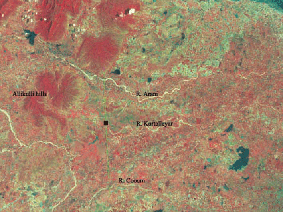
Satellite remote sensing was used to address both research projects and for developing a heritage management plan for Prehistoric archaeological sites in Tamil Nadu. This project was undertaken in collaboration with Regional Remote Sensing Centre-South, NRSA, ISRO, Government of India.
You can read more in our Research publications.
Satellite images at differing resolutions (IRS 1D LISS 3 of 23 m, IRS 1D PAN + LISS 3 merged satellite data of 5.8 m, IKONOS 1 m) were used in a GIS platform to generate thematic maps addressing v arious issues related to research, impact assessment, and heritage management planning.
Research
In combination with field and laboratory studies, we were able to investigate over 200 prehistoric sites and areas of interest for Quaternary environments over an area of around 8000 km2, in northern Tamil Nadu in relation to geological and geomorphological features.
We were also able to demarcate sources of raw materials used for the manufacture of stone tools through time. Around 200 sites/sections were studied in detail, ranging in age from the Acheulian to the microlithic. Studies of the nature of the lithic assemblages, geomorphology and chronology are in progress.
Impact Assessment Studies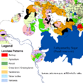
Sites are being rapidly destroyed by infrastructure development and mechanised agriculture. Owing to this purpose we included a component of impact assessment and heritage management planning in our project. For this purpose, we quantified the nature, intensity, and area of modern landuse patterns impacting sites from both field studies and from satellite images.
Overlays of georeferenced village cadastral maps on rectified high-resolution IKONOS data provided exact landuse and ownership details, to suggest site-specific conservation strategies.